Description
As new GPS-Receiver with accessories and latest NavData-Update (voucher)
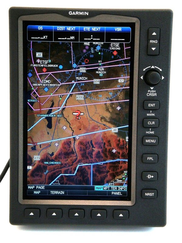
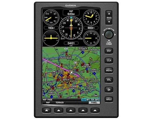
The unit features a moving-map GPS with view from space graphics, a rotary joystick cursor, a softkey interface, a fast 5 Hz screen updating, and database driven terrain and obstacle alerting. Maps can be displayed in VFR or IFR modus. In the IFR modus it shows Low as well as High airways.
The display can be individually configurated - map view only, map view combined with a selection of data fields (panel page) or data fields only.
The Garmin GPSMAP 695 runs with a rechargeable, replaceable Nickel-Metal Hydride battery - 2.5 hours with full backlight adjustment, up to 8 hours with 50 % backlight adjustment. As interfaces the unit provides a SD card slot, an external GPS antenna connector (MCX), an Audio (headphones) Line Out, a Mini-USB connector, and an external Power / Serial Port Connector.
With an optional adapter cable in connection with Zaon Anti-Collision-System XRX you can display traffic information on your GPSMAP 695.
The Garmin GPSMAP 695 features also well known utilities such as Smart Airspace, flight log, track log, E6B calculator, aircraft profile settings, weight & balance settings, and proximity waypoints.
VFR reporting points and obstacles (upon 300 ft.) are also included.
So, check it out - the visionary Garmin GPSMAP 695, the ultimate portable MFD (multi function display).
Physical & Performance:
- Unit dimensions (WxHxD): 5.7' x 7.7' 2.0' (14.5 x 19.5 x 5.1 cm).
- Display: 3.6' W x 6.0' H, 7.0' diagonal, 480 x 800 pixels, WVGA TFT with adjustable backlighting.
- Weight: 35.7 ounces (1,012 g) incl. battery pack.
- Battery: rechargeable, replaceable Nickel-Metal Hydride.
- Battery life: up to 2.5 hours with full backlight, up to 8 hours with 50% backlighting.
- Voltage range: 11-40 V.
- Receiver: high-sensitivity.
- Interfaces: SD card slot, Mini-USB, Audio Out, MCX-Connector, serial RS-232.
Maps, Databases & Memory:
- Basemap: yes, worldwide.
- Terrain and Obstacles database: yes.
- Jeppesen database: yes, Atlantic International (ATI), new Update before delivery!
- VFR-Traffic patterns from platzrunden.de
- Preloaded low & high altitude enroute airways: yes.
- IFR map mode: yes.
- Preloaded maps: no.
- Ability to add maps: yes, Mapsource based.
- Accepts data cards: yes (SD cards only).
- Built-in memory: internal solid state.
- Waypoints / favorites / locations: 3,000.
- Routes: 50.
More product features:
- Moving map: yes.
- Instruments page (Panel): yes.
- Built-in VHF Comm: no.
- External VHF Comm: no.
- Built-in HSI: yes.
- Audible terrain & obstacle alerts: yes.
- Smart Airspace Feature (generates / displays altitude-sensitive alerts): yes.
- Separate serial / USB interfaces: yes.
- Automatic logbook: yes.
- Voice prompts (e.g. 'Turn right in 500 ft.'): no.
- 3-D map view: no.
- Custom POIs (ability to add additional points of interest): no.
Delivery comprises:
- Base map and Jeppesen air space data base "Atlantic" inlcuding airfields, NavData Update after order and before delivery!
- airports and landing strip data (partly), air spaces, VORs, NDBs and Waypoints, VFR Compulsory points as well as cities, streets, rivers and lakes...
- USB cable to connet to a PC for updating, Update also possible with the inserted SD card
- Wall Charger cable
- Power Supply Cable for cigarrette lighter jack
- flexible cover to protect the display while not in use
- Voucher for one NavData Update. We can alternatively update the device before delivery!
Free shipping within Germany!